Home > Places to Explore > San Pedro Riparian NCA
San Pedro Riparian NCA (National Conservation Area)
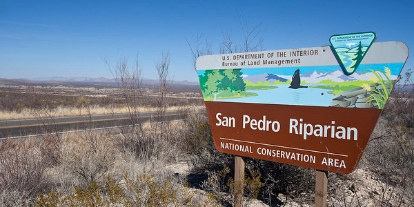
photo courtesy of Bureau of Land Management
Location: Various access points - main access at San Pedro House
Directions: To San Pedro House - from Tombstone take S. Charleston Road to Moson Road, turn left, go to AZ State Highway 90, turn left, go about 3 miles, turn right, San Pedro House will be on your left
GPS Coordinates: 31.56950715480063, - 110.18970951047018
Address: 9800 AZ-90, Sierra Vista, AZ 85635
Phone: Visitor Center (520) 508-4445
Hours: San Pedro House open 9:30 am to 4:30 pm, daily
San Pedro Riparian NCA always open year round
Admission Fee: None
Facilities: Restrooms, potable water, and wheelchair-accessible picnic tables are available at the San Pedro House
Handicap Access: At the San Pedro House, not in all other areas - check specific information in Visitors Center at San Pedro House
Things to Do: Interpretive walks, guided hikes, historic and pre-historic site viewing, hiking, biking, birding, camping, hunting, fishing
Cochise County holds the distinction of having the United States' first ever Riparian National Conservation Area (NCA). Lucky us.
Formed by Congress in 1988, the San Pedro Riparian NCA stretches 40 miles along both sides of the San Pedro River from the border with Mexico to just south of Benson, AZ.
The San Pedro Riparian area consists of almost 57,000 acres and hosts 84 species of mammals, 14 species of fish, 41 species of reptiles and amphibians, and 100 species of breeding birds.
It also provides habitat for as many as 250 species of migrant and wintering birds (more than half of the known breeding bird species in the U.S. have been sighted here) making the San Pedro Riparian NCA very popular with bird watchers.
A Ripe What?
A riparian (rye-pare-ee-an) area is where the land and a flowing river or stream come together. Also called a riparian habitat, it is the river itself, as well as the banks along both sides.
Considered a unique "habitat" for plants and animals, "riparian area" is a poorly-defined term that can include everything from raging rapids and the cliffs they run through (NOT the San Pedro!), to stagnant swampland that breeds vermin and disease like mosquitos and malaria.
Which, by the way, is what the San Pedro River used to be before the earthquakes in the late 1800s and early 1900s in southern Arizona and northern Sonora, Mexico 'sank' the river and dried up most of the swamps in Cochise County.
The San Pedro River Today

photo courtesy of Bureau of Land Management
The San Pedro is not the wide, shallow, slow-moving river it was prior to the earthquakes when cattlemen, settlers, and even the miners came along during the late 1800s and started cleaning it up with cattle grazing and by drawing water from the river for various uses.
But it is not the abundant, useful water source that it was in the late 1800s, either.
Now the river is a pathetic trickle of its former self that frequently runs dry in hot months. The loss of water is NOT due to drought, nor to the use of groundwater pumped out of wells, however.
As mentioned above, there were at least two earthquakes centered in northern Mexico around the turn of the last century (1900) that caused changes in the underground aquifers in Cochise County.
As a result, many springs in the county dried up, making the range land dry out and turning grasslands to scrub (called 'desertification').
This is when the flooding in the Tombstone mines greatly increased, eventually leading to the shut-down and abandonment of the mines, and then the town.
From these changes the San Pedro River 'sank,' meaning more than half of the water that had flowed on the surface went underground, drying the river down to less than half its width.
But, on the upside, the lakes around St. David soon appeared where they hadn't been before, most of which are fed by natural artesian springs.
The current state of the San Pedro as a struggling, ever-decreasing above-ground river is also due to gross mismanagement by the federal government and a whole slew of 'do-gooders' who think they know stuff, but don't.
The BLM (No, Not That One)
The San Pedro Riparian NCA is now public land overseen by the Bureau of Land Management (BLM), based in Washington, D.C.
The stated goal of the San Pedro Riparian NCA project was to "protect a fragile ecosystem" of the river, along with all the native plants and animals that live along it.
Unfortunately, the result of more than 35 years' worth of "protection" has been the drying up of the river for much of the year and the degradation of the riparian areas along side of it.
How Did "Protection" Harm the River?
The biggest influence on this negative result has been the mesquite tree.
Arizona range management experts (people who actually live here and know this environment, as opposed to Washington, D.C. wonks who know nothing) classify all species of mesquite as noxious weeds (meaning harmful). Mesquite are also known as "water miners."

mesquite trees
Mesquite trees send taproots down as far as 1200 feet and pull up all available water, dumping it through expiration into the air. This, of course, will severely lower the water table (including river surface water) if there are enough mesquite in the area.
Too many mesquite is exactly what happened to the San Pedro when the ignorant, badly-educated 'back-easters' took control of the area, threw off all the cattle (which will eat immature mesquites) and the cattle ranchers (who will pull up and kill mesquite that the cattle don't get), to let the river "go back to nature."
The mesquite proliferated, the river has dang near dried up, and the 'saviors' of the San Pedro are still scratching their heads screaming, "It must be a drought!" or worse, "It must be the people using up all the groundwater!"
Isn't nature a bi..., well, let's leave it at that.
How to Tour the Boondoggle... er, NCA
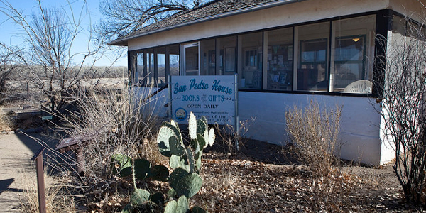
photo courtesy of the Bureau of Land Management
Start at the San Pedro House
The best place to start exploring the San Pedro Riparian NCA is at the San Pedro House.
This historic ranch house dating from the 1930’s has been restored and serves as a focal point for learning about the San Pedro River and surrounding areas.
Several trails leading to various points of
interest begin at the San Pedro House and short, wheelchair accessible trails leading from
the ranch house offer a good overview of what the San Pedro Riparian
NCA has to offer.
There is a self-guided Interpretive Nature Trail
that features markers with information about the different ecosystems
and points of interest, including an easy trail to a cottonwood grove
and a loop trail through the riparian forest overlooking a small wetland
called Kingfisher Pond.
The San Pedro House itself now serves as a
visitor center and bookstore operated by the Friends of the San Pedro
River. There visitors can find maps, brochures and other information
about the NCA.
The Friends of the San Pedro also lead guided nature, history and bird walks from the San Pedro House.
Call ahead for the schedule of guided walks, hikes and children’s programs.
The San Pedro gift shop and bookstore is open 9:30 a.m.–4:30 p.m. daily.
Other Facilities Available
San Pedro House has wheelchair-accessible restrooms and picnic tables.
Water is available from both drinking fountains and ground spigots.
First Aid is NOT available here. The nearest hospital is in Sierra Vista.
The Whole San Pedro Riparian NCA
The NCA provides opportunities for wildlife viewing, birdwatching, picnicking, primitive camping, and visiting prehistoric and historic sites,
Hiking, fishing, biking, hunting, horseback riding, guided hikes, interpretive site visitation, and children’s programs are also available.
Birdwatching is best in the spring and fall.
Camping is only allowed in the backcountry and permits are required. Permits are available any time from the self-service pay stations at visitor parking areas. Camping in parking areas is prohibited.
Accessing the San Pedro Riparian NCA

There are many other access points to the San Pedro Riparian NCA besides the one at the San Pedro House.
Parking, interpretive kiosks, and trailheads can be found at Fairbank,
Murry Springs, St. David Cienega Land Corral, Terrenate, Millville, and
Hereford Bridge.
Parking and trailheads are also available at Hereford Road, Charleston Road, Palominas, Escapule, and Lehner.
Other main entrances to San Pedro Riparian NCA are:
- Arizona Route 80, near St. David;
- Arizona Route 82 to Fairbank;
- Charleston Road to Millville Historic Townsite;
- Hereford Road to Hereford Bridge; and
- Arizona Route 92 to Palominas.
For more information on these access points pick up brochures at the San Pedro House visitors center.
For detailed topographic maps of the San Pedro Riparian NCA, click here.
Safety Warning
The San Pedro River is subject to seasonal flooding, including flash floods and summer monsoons (rain storms) are common.
Stay out of the river and any dry washes during summer months (June through September).
DO NOT CAMP in any washes (dry creek beds) at any time of the year.
The region is also a travel corridor for illegal immigrants coming north from Mexico.
Avoid contact with people exhibiting suspicious behavior or engaged in dangerous activities.
Report all suspected illegal activities to local law enforcement via 911.
Home > Places to Explore > San Pedro Riparian NCA
COCHISE COUNTY
Coming Events
Rex Allen Days in Willcox - Oct. 2-5, 2025
Bisbee 1000 Great Stair Climb - Oct. 18, 2025
See More...